How to protect the heritage of the Grand Canal? New technology guards "mobile civilization"
Jiangsu is the province with the longest river route, the richest related heritage and the largest number of World Heritage sites listed in the Grand Canal in China. Until today, the Jiangsu section of the Grand Canal is still the "golden waterway" for national transportation and the South-to-North Water Transfer Project. How to protect the precious heritage left by our ancestors? Recently, the reporter interviewed experts related to the heritage protection of the Grand Canal to see how science and technology can protect the "flowing civilization".
"The Jiangsu section of the canal runs through 790 kilometers from north to south, with 7 canal heritage areas, 22 world heritage sites and 6 heritage river sections, and is rich in cultural heritage and tourism resources along the route." Liu Huaiyu, deputy dean of the China Grand Canal Research Institute of Yangzhou University, said that the heritage protection of the Grand Canal is mainly divided into three aspects. The first is the heritage itself, that is, the river; Secondly, the water body closely related to the river, for example, as a tributary of the ancient canal, Yangzhou Slender West Lake is also listed as a world cultural heritage; In addition, ancillary facilities related to the canal are also listed as the scope of protection. "In the past, people could only rely on regular inspections by manpower to protect the heritage of the Grand Canal, and their information was not comprehensive and timely. Now, with the help of new technology, the efficiency of heritage protection has been greatly improved."
Wumenwangting, Hushuguan, a night-mooring near maple bridge … … The Grand Canal passes through Suzhou’s "Ten Scenes of the Canal", leaving a unique scenery along the canal. Behind the beautiful scenery, the integrated protection measures of "empty heaven and earth" introduced by Suzhou Cultural Relics Protection Management Office contributed greatly. "In order to better obtain the overall data of Suzhou Grand Canal heritage ontology and buffer zone, Suzhou Cultural Protection Institute has innovated and improved the protective monitoring in three dimensions: underwater, water surface and air, and launched a series of new technologies for data collection." Yuan Qionglan, deputy director of the Grand Canal Heritage Exhibition Hall of Suzhou Cultural Relics Protection Management Office, told the reporter that in 2014, Suzhou Wenbao took the lead in applying remote sensing technology to the monitoring of the Grand Canal heritage in China. Because remote sensing technology mainly monitors the external environment of the Grand Canal, but lacks the monitoring of the heritage itself, relevant experts began to explore the establishment of the overall monitoring system of the Grand Canal heritage.
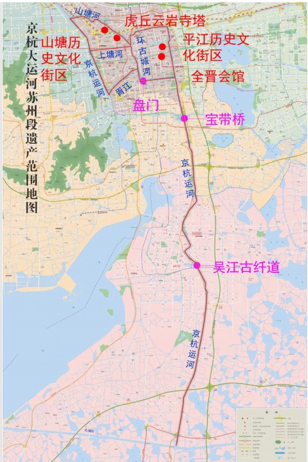
Heritage scope of Suzhou section of the Grand Canal
Yuan Qionglan said that in order to break the bottleneck that it is difficult to obtain riverbed morphological data in shallow water and ultra-shallow water, Suzhou Wenbao Institute adopted a multi-beam sounding system to realize "CT scanning" of underwater riverbed. Depending on the scanning results, digital results such as riverbed model and section map can be realized, and they can be digitally archived, and the specific shape of riverbed can be moved into the computer and put into the "physical examination" file of the canal heritage. "The multi-beam bathymetric system can be used to obtain the full coverage bathymetric data of the riverbed, and finally the following series of riverbed diagnosis can be completed. In other words, with this system, we can periodically ‘ Physical examination ’ 。”
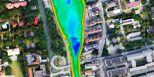
Digital achievements based on "CT scanning"
In addition, a set of measurable river view acquisition system, which is composed of laser scanning system, image acquisition system, positioning and attitude determination system and auxiliary hardware system, can complete the measurable image data acquisition of the water surface revetment and bridge of the Grand Canal. The application of this kind of measurable system not only enriches the contents of digital archives of canal heritage, but also provides image support for managers to "diagnose" the present situation of canal preservation, and shows the scenery along the canal, which makes the heritage points of the canal and the canal culture beautiful and echo each other.
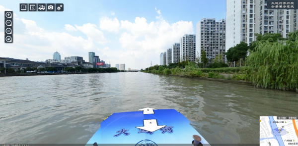
Measurable river view results
"The monitoring of the Grand Canal heritage is a long-term project with a wide range and a large quantity. We innovatively adopt ‘ Point ’ ‘ Line ’ ‘ Face ’ The trinity aerial monitoring method has realized the grand canal as a whole ‘ Physical features ’ Acquisition of visual files. " Yuan Qionglan explained that through aerial real scene, aerial video and orthophoto map technology, we can find out the changes of land use information such as greening, water system, buildings and roads in the heritage area and buffer zone, and provide scientific basis and technical support for the daily monitoring management and protective planning and utilization of the Grand Canal.
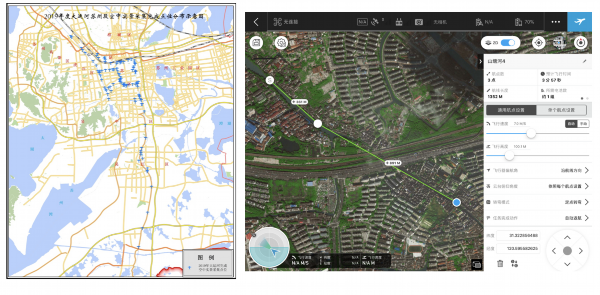
Point distribution map of aerial real scene and schematic diagram of fixed route of aerial video
“‘ Empty world ’ The application of integrated technology allows us to discover land use change plots in heritage areas and buffer zones in time, which is an important part of the heritage protection of the Grand Canal. " Yuan Qionglan said that the long-term ontological health data such as the stability of the revetment and the internal situation of the riverbed collected through the all-round monitoring system were shared with relevant departments. For example, in 2020, the data of riverbed scanning played an important data support in the process of river dredging.